- -- - -- - -- - -- - -- - -- - -- - -- - -- -

Art--Animals--Food--Links--Lists--Map--Movies & TV--Music--Nature--Places--Performances--Souvenirs--Structures--Timeline

Wednesday, 20 July 2016

Fork in the Road (Strange Brew)

Where should we go?  Loonie bin or brewery?

Location: Scarborough, Ontario, Canada
Address: 1 Brimley Road South
Date: Nov 2014
Website:  www.toronto.ca

  In the movie Strange Brew, Bob & Doug Mckenzie drive to a fork in the road and have to decide which way to go.  They have to use the signs to decide between Elsinore Castle, Elsinore Research & Development, Elsinore Brewery, or the Royal Canadian Institute for the Mentally Insane.  Geez there's a lot of arrows eh?  In reality there are four different Toronto locations that have been composited into the film.  We have added our own re-creation at the top of this blog using photos from when we visited the real life locations.
 
Looking up Brimley Road from Scarborough Bluffs (June)

  The main location is at the bottom of the hill that leads down to Bluffer's Park in Scarborough.  The brothers encounter their signs where the red "Do Not Enter" sign is located.  Once they decide to continue on and try to get their money from the brewery, they go up the road on the left.  This is actually against traffic as it is usually one way southbound.  We have taken photos at the Bluffs countless times, but never a picture looking up the road.  It is the Bluffs themselves or Lake Ontario that make for the best photo opportunities.  The first time we went to take our picture was in June (above), but it didn't quite look right with all the green trees.  We ended up returning again in the fall and finally got the shot we wanted (below).

Looking up Brimley Road from Scarborough Bluffs (November)

  On the left side of the hill is Elsinore Castle, which is played by Casa Loma.  Casa Loma was completed in 1914 and has stood watch over Toronto ever since.

Sure looks spooky up there.  I don't like the look of this at all. (Casa Loma)

  Near the center of the road is Elsinore Brewery which  is played by the R.L. Hearn Generating Station.  The station was used for electrical generating since the 1950s and decommissioned in 1983.  That is the same year that Strange Brew was released.  The movie added the big Elsinore name using special effects.  There was some additional filming done at this location when Bob & Doug arrive at the brewery and walk through the parking lot.  You can read more about this location here.

It's real big eh?  Yeah, but don't get scared.  Just think of all the free beers we're gonna get.

  We also used another picture we had taken during a day spent sailing on Lake Ontario.  Here you can see the huge chimney and the line of hydro towers heading away from the station.  The hydro towers appear to be used in the composite along with 2 chimneys.  We couldn't quite figure out the best angle to get all of this in one picture.

Hearn Generating Station

Finally, the R.C. Harris Water Filtration Plant plays the part of the Royal Canadian Institute for the Mentally Insane.  It is located up on the hill to the right.  It plays a bigger role in the film at the end when it catches on fire.  An extremely beer bloated Bob saves the day by relieving himself on the fire.  He does in two minutes what would have taken the fire department two hours.  You can read more about this location here.

Hey that's the looney bin eh!

You take all of these locations, mix them up into one shot and you sure have a Strange Brew of Toronto landmarks eh?

Map of Our World
Fork in the Road (Strange Brew)
Casa Loma , R.L. Hearn Generating Station , R. C. Harris Water Treatment Plant
Bluffer's Park

Post # 123

Friday, 15 July 2016

Molson Indy

This is the race.

Location: Toronto, Ontario, Canada
Address:  Exhibition Place
Date: July 2003
Website:  www.hondaindytoronto.com

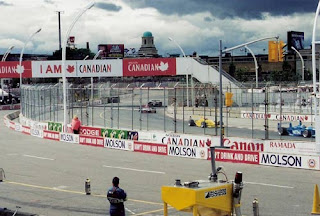
   Once again engines will roar down by the lake!  The Honda Indy 2016 will take over the Exhibition Place grounds from July 15 to 17.  Back in 2003 when we attended the event it was still sponsored by Molson "Don't drink and drive" Brewery.

Ready for the race.

  The barriers and grandstands have already been put into place well before event weekend.  We took the photo above near Lakeshore Blvd. and Newfoundland Drive.  Exhibition Place has a street named after each of Canada's provinces and territories except for one.  There is no street representing the Northwest Territories.  Perhaps Northwest Street was deemed too confusing for drivers?  When the racing weekend finally arrives if you are on any street near the Exhibition grounds you will hear it. 

These seats are good.  The ones in front of us are the pits.

  We were lucky enough to have seats right behind the pit lane.  This gave us a front row seat to watch the pit crews in action.  They perform a well choreographed routine when their driver pulls in.  Tires are removed and changed and both the car and driver get some much needed refueling.  Every second counts until the driver is back out on the race track.

Pit crew in action.
That was the pits.

  The cars raced past us at average speeds of around 100 miles per hour.  We took lots of photos and we had to time it just right in order to catch a vehicle in our shot.  You could hear the noise of a vehicle as it changed gears and came around the bend and then roared ahead as it entered the straightaway.

Hang on lady, we going for a ride!

  The only time it was easier to film the Indy cars was when there was a caution on the track and the pace car was released to lead the vehicles.  The Indy cars are actually Champ Cars that get their name from the most famous race, the Indianapolis 500.

Keep Up The Pace.

  The 2003 race was won by Paul Tracy from Scarborough, Ontario, Canada.
 
Rock the CASCAR.

  Over the course of the day we also witnessed a CASCAR stock car race.  CASCAR stands for the Canadian Association for Stock Car Auto Racing.  Their pit crews must roll out the equipment and set up on the pavement in front of the Indy car pit lane.  That race was followed by a Formula 1600 race.  Eventually the race day had to come to an end and the engines fell silent.

On the fast lane of the street I'm driving.

 You can drive through the Exhibition grounds yourself while the barriers are still in place and pretend you are on your victory lap.  Keep in mind that while race car drivers are paid to push their cars to the limit, the rest of us will have to pay if we don't obey the traffic laws.


Map of Our World
Molson Indy (Honda Indy)

Post # 122

Sunday, 10 July 2016

Confederation Bridge

Rolling down the highway smiling.

Location: Prince Edward Island, Canada
Address: Confederation Bridge
Date: July 2006
Website:  www.confederationbridge.com

  If you wanted to bring a car to Prince Edward Island you used to have no choice but to do it by boat.  In May 1997 the Confederation Bridge opened and allowed people to drive across to the island.  The good news is that if you wish to visit Canada's smallest province it is free to drive across.  The bad news is that you will have to pay if you ever want to leave again.

Entrance to Confederation Bridge.

  The bridge took about three and a half years to build.  It spans 13 kilometres over the Northumberland Strait.  It starts in the province of New Brunswick and ends in PEI.  When we last checked, the toll was about $50 per vehicle to leave PEI again.

And they're from Prince Edward Island. They're from Prince Edward Island.

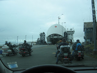
  Another option for leaving Prince Edward Island is to take the ferry.  We chose this option.  The ferry will cost you as well so don't think you are getting away without paying your fair share.  As our trip was taking us further east this option made the most sense.  We drove from Shediac, New Brunswick to Cavendish, PEI.  After a few days visit we headed east again to Wood Islands, PEI where we caught the ferry to Caribou, Nova Scotia.  It was then eastern bound once more to Halifax, Nova Scotia.

Ferry from Wood Islands to Caribou.

  We had crossed the Confederation Bridge in a downpour and the rain stayed with us while we were on the island.  Despite the grey skies, our ferry trip allowed us to get up on the deck and finally get some fresh sea air.   The mud in PEI is red due to its high iron-oxide content.  Our ferry set sail and we left the red mud of Prince Edward Island behind.  We vowed to return when the sun was shining to check out this province once again.  Hey,  it wouldn't even cost us anything to drive over there.

It's the bright red mud.


Map of Our World
Confederation Bridge
Wood Islands to Caribou Ferry

Post # 121